Donate to Our Spring Campaign or Bid on our Spring Auction to Support Forecasting

Forecast for the Ogden Area Mountains

Drew Hardesty
Issued by Drew Hardesty on
Wednesday morning, February 8, 2023
The avalanche danger will be on the rise today with new and developing soft and hard slabs of wind drifted snow. Expect a MODERATE avalanche danger in the wind zone of the mid and upper elevations, predominantly on steep north to east to south facing slopes. Human triggered.... and shallow natural avalanches... will be possible.
Low angle sun and wind sheltered slopes will be the best bet for today.
Low
Moderate
Considerable
High
Extreme
Learn how to read the forecast here
Weather and Snow
Skies are partly-trending-mostly cloudy.
Mountain temperatures are in the upper teens and low 20s.
Winds are from the west-northwest, blowing 15-20mph with gusts to 25.
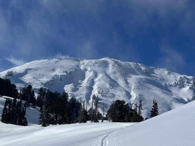
Sun and wind crusts are fairly widespread (note extensive wind damage on Ben Lomond), but you can find decent riding conditions in the sheltered terrain.
Eric Trenbeath, Pete Groves and Kory Davis toured around the Cutler area yesterday and their report is HERE>. Derek DeBruin's report from Rodeo Ridge is HERE>
(photo Eric Trenbeath)

We'll see increasing clouds and winds today with of a storm system passing by to the north. A mostly dry cold front pushes through mid-afternoon, allowing temperatures to drop to the teens today and the single digits for tonight. Winds will only gather steam and start to howl out of the northwest. Unfortunately, we'll only see an inch or two for the trouble. Our partners here at the NWS is calling it a "squally storm", with strong winds and poor visibility by late afternoon, particularly in areas north of I-80. High pressure along with a warming trend follows for the rest of the week with a storm system diving well south of the area over the weekend. The long range models look interesting.
Recent Avalanches
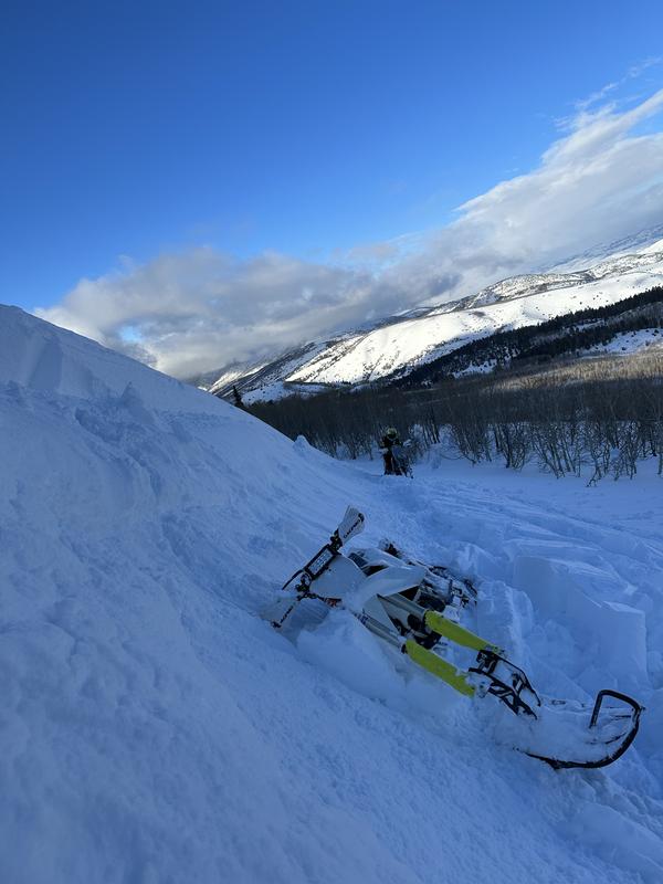
We didn't hear of any avalanche activity yesterday, but we did get a report of a snowbike-triggered soft slab of wind drifted snow north of the Monte Cristo area near Cinnamon Creek. It was reported as a foot deep and 100' wide on an east facing slope at 7900'.

See the full list of avalanche activity where you can filter avalanches by region and date.
Ad
Avalanche Problem #1
Wind Drifted Snow
Type
Location
Likelihood
Size
Description
New and developing soft and hard slabs of wind blown snow will be your primary concern for today.
The newest drifts are currently relegated to the higher elevations on primarily north to east to south facing aspects, but they'll become larger and more widespread as the day wears on. Today's new soft slab avalanches will be particularly sensitive and may be triggered at a distance.
On some shady slopes, these new soft slabs may step into some buried weak layers buried about a week ago. Mark Staples and his partner found generally Low avalanche danger in their travels along the Bountiful skyline yesterday, but noted this old surface weakness buried about a foot deep.
Note that cornices may start to calve with the searing winds today as well.

How can you recognize new soft slabs of wind blown snow? Cracking and collapsing are definite signs, but look for rounded, scalloped pillows to the lee of ridge and subridges and around other terrain features such as rocky outcroppings. MORE INFO
Below - classic photo of wind drifting into a slab avalanche to the lee of a ridgeline in Alaska by Doug Fesler
Additional Information
Check out the updated guidance on electronic interference and beacons HERE. The 20/50 rule is that you want your beacon 20cm (8") away from other electronics while transmitting and 50cm (20") away from electronics while searching.
General Announcements
This information does not apply to developed ski areas or highways where avalanche control is normally done. This forecast is from the U.S.D.A. Forest Service, which is solely responsible for its content. This forecast describes general avalanche conditions and local variations always occur.