Donate to Our Spring Campaign or Bid on our Spring Auction to Support Forecasting

Forecast for the Ogden Area Mountains

Dave Kelly
Issued by Dave Kelly on
Tuesday morning, February 7, 2023
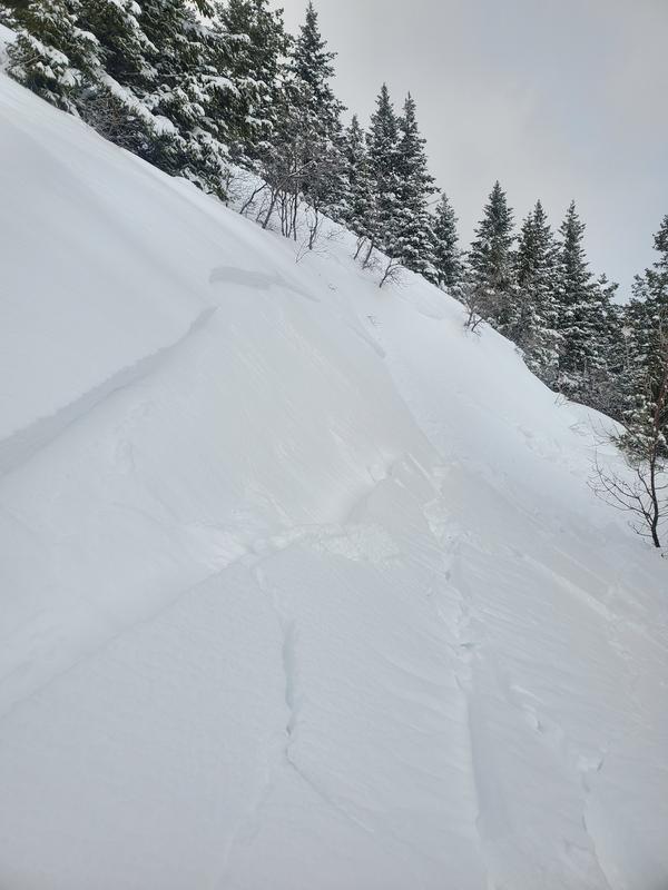
There is a MODERATE danger on upper and mid elevation slopes where human triggered avalanches are possible in the new and wind-drifted snow. These avalanches will be 1-2' deep. There is a LOW danger on lower elevation terrain where there has been less new snow.

Human triggered avalanches are POSSIBLE on slopes where the new snow has drifted into a harder slab of dense snow, or on steep slopes where the sun has warmed the surface snow. A great option is to let the new snow settle out and stick to lower angle objectives where there is good powder-snow riding.
Low
Moderate
Considerable
High
Extreme
Learn how to read the forecast here
Weather and Snow
Under partly cloudy skies trailhead temperatures are 18-22 F while the highest ridgeline temperatures are in the low teens F. Winds are blowing 15 to 20 MPH from the northwest at the 8000' ridgelines and 20 gusting to 25 MPH at the 9,000' ridgelines. Today, winds will blow from the north-northwest 5 to 15 MPH at the 8000' ridgelines and 20 to 35 MPH at the 9,000' ridgelines. Winds will shift to the north and decrease throughout the day. Skies will be partly cloudy with temperatures 28-32 F. No new snow is expected today. The freezing level will rise from 4000' to 5000' feet throughout the day.

Storm Totals (total height of snow)
  • Ogden Area Mountains 6-12" snow/ .6-.1.5" water storm totals (total depth 90-125")
Recent Avalanches
Yesterday, riders reported loose dry avalanches running on a density change within the new snow and wind-drifted avalanches in upper elevation terrain 10-12" deep. There was a close call in the Primrose Cirque in the Provo area mountains where a skier triggered a wind-drifted slab of snow and was caught and carried on a steep north facing slope at 8500'. This avalanche was 12" deep and 60' wide. This avalanche is similar to what I would expect to find in steep alpine terrain in the Ogden area mountains and is a reminder that even mid-elevation terrain can resemble high alpine terrain under the correct conditions.

See the full list of avalanche activity where you can filter avalanches by region and date.
Ad
Avalanche Problem #1
Wind Drifted Snow
Type
Location
Likelihood
Size
Description
Today, it will be possible to trigger slabs of wind-drifted snow 1-2' deep. You may be able to get further out onto a wind-drift before it breaks with the additional weight of a rider. Keep an eye out for snow drifts and smooth rounded deposits of snow on leeward slopes and in cross-loaded areas.
Wind-drifted snow avalanche 6-8" deep on the North Ogden Divide (Photo- E DeJong)
Avalanche Problem #2
New Snow
Type
Location
Likelihood
Size
Description
Human triggered avalanches are possible on steep northerly facing terrain and on the sun crust on southerly facing slopes up to 1' deep. Avoid traveling on or under any steep sun warmed slope as any hint of sun is more than enough to trigger natural avalanches on steep slopes, road cuts, or roofs.
Additional Information
Check out the updated guidance on electronic interference and beacons HERE. The 20/50 rule is that you want your beacon 20cm (8") away from other electronics while transmitting and 50cm (20") away from electronics while searching.

Wednesday February 8th... save the date and take a date-
Please join Craig Gordon in partnership with WNDR Alpine, Wednesday February 8th at 5:00 for a State of the Snowpack prezo at Woodbine Food Hall. It'll be fun, informative, and potentially entertaining. All the deets are found HERE.
General Announcements
This information does not apply to developed ski areas or highways where avalanche control is normally done. This forecast is from the U.S.D.A. Forest Service, which is solely responsible for its content. This forecast describes general avalanche conditions and local variations always occur.