Donate to Our Spring Campaign or Bid on our Spring Auction to Support Forecasting

Forecast for the Ogden Area Mountains

Nikki Champion
Issued by Nikki Champion on
Tuesday morning, January 4, 2022
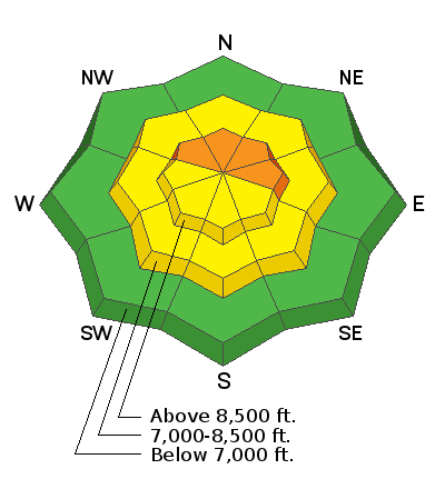
The avalanche danger is CONSIDERABLE on upper elevation slopes facing northwest through north and east. Avalanches may break down 2-8' deep (possibly deeper) and hundreds of feet wide. Natural avalanches are possible, and human-triggered avalanches are likely. Avoid this terrain because those avalanches will kill you.
Watch for and avoid any freshly formed wind drifts on all mid and upper elevation slopes. A MODERATE avalanche danger exists on west and south-facing mid and upper elevations as well as mid-elevations facing northwest, north, and east. A LOW avalanche danger exists on low elevation slopes.
Pay attention to changing weather patterns. As this next storm system develops, it will bring new snowfall, warm temperatures, and high winds, with that the avalanche danger will rapidly rise.
Low
Moderate
Considerable
High
Extreme
Learn how to read the forecast here
Weather and Snow
Temperatures this morning are in the upper teens to low 20s F. Since Sunday, winds have been cranking in Ogden and will continue to increase into the morning. At mid-elevation bands, they are blowing 20-30 mph gusting 45 mph. At the upper elevation ridgelines, they are gusting near 90 mph. They are blowing primarily from the West, but some zones are blowing from the east and northeast as well.
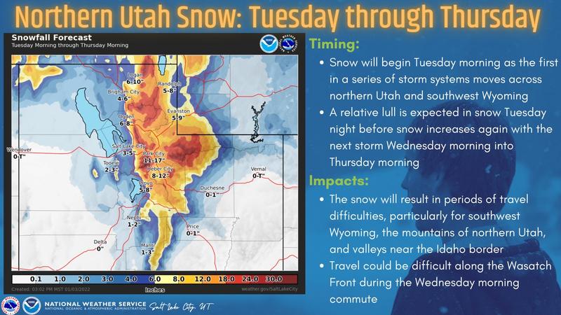
Today temperatures will generally rise to the upper teens F, but lower elevation locations should have temperatures in the mid-20s F. Clouds will continue increasing into the morning, bringing light snowfall and high winds. Snowfall rates should remain less than one inch an hour today, with peak snowfall rates between the late morning and early afternoon. We can expect 3-6" of new snow by dinner. Winds will continue to increase throughout the morning and transition more westerly. Winds will blow 20-30 mph, with gusts up to 35 mph at mid-elevations. At upper elevations, gusts may reach up to 70 mph.
While we get a bit of snow today, it will taper off this evening and the heavier snowfall arrives Wednesday morning to Thursday morning. This storm looks like it will have strong winds, increasing temperatures, and increasing snow densities.

Warm temps and a few days of intermittent sunshine have warmed the snow on south-facing slopes and most will have a slight crust this morning. Coverage is fantastic, and settled snow depths, even at lower elevations are 3-4 feet. Upper elevation areas and the upper cottonwoods have snow depths up to 6-7 feet.
Recent Avalanches
Yesterday, there were no new avalanches reported in the backcountry, but reports from avalanches triggered this past weekend continue to roll in. Ski resorts are reporting natural cornice fall and large avalanches with explosives.
View all the recent avalanche activity HERE.
Ad
Avalanche Problem #1
Wind Drifted Snow
Type
Location
Likelihood
Size
Description
This morning, winds are cranking in Ogden, with gusts near 90 mph. The winds have been elevated since Sunday and moving a ton of snow around. Sunday, a regular observer near Ben Lomond Peak observed increased west winds moving snow at mid-elevation ridgelines (see video below). These fresh wind slabs weren't reactive yesterday, but maybe today.
For the snowpack, when the winds drift snow, it's the same as if snow is falling out of the sky. The snowpack doesn't care where the snow comes from, it feels the added weight. So, on northerly facing slopes, these winds have added snow and weight, and stress to the avalanche problem listed above.
While these winds have mostly formed drifts on northerly facing slopes, they can load any slope because winds swirl and change direction as they pass through the mountains. What to do? Avoid any steep west, north, or east-facing terrain that has avalanche problems listed above. If riding south-facing avalanche terrain, look for evidence of fresh drifts and wind slabs that look wavy, rounded, smooth, and pillowy and avoid them as well. Fortunately, those fresh drifts are easy to see and go around.
Cornices: With such strong winds, cornices continue to grow. There have been reports of natural cornice falling within ski resorts. Give these cornices a wide berth, as they often break farther and deeper than expected. Any cornice fall could trigger a much deeper avalanche within the old faceted snow.
Avalanche Problem #2
Persistent Weak Layer
Type
Location
Likelihood
Size
Description
The situation is very simple - there is a persistent weak layer (PWL) of old, faceted snow near the ground with 3-4 feet of snow on top of it that can avalanche. Winds increased from the south and have likely been loading the slopes where this PWL exists.
This layer exists on north, and east-facing slopes where old snow lingered and weakened in November and was buried by December snowfall. This layer seems to be fairly widespread at upper elevations above 8,500 feet and more spotty at mid elevations. It doesn't exist on south and west facing slopes because it melted away in November, and December snowfall landed on bare ground on those slopes.
Since Christmas Eve, snowfall containing up to 6 inches of water has been added to the snowpack. We focus on water amounts because that tells us how much weight is added to the snowpack. For a slope the size of a football field, snow with 6 inches of water weighs 2,100,000 pounds. Imagine that amount of snow crashing downhill.
How will we know when this avalanche problem heals? That's a tough question to answer, and we mainly have to let the snowpack answer it. For now, avalanches are still happening and that's all I need to know. As we look into the future, it will heal, but I can't tell you when. We will be monitoring the snowpack and avalanche activity and keep you updated.
General Announcements
Who's up for some free avalanche training? Get a refresher, become better prepared for an upcoming avalanche class, or just boost your skills. Go to https://learn.kbyg.org/ and scroll down to Step 2 for a series of interactive online avalanche courses produced by the UAC.
This information does not apply to developed ski areas or highways where avalanche control is normally done. This forecast is from the U.S.D.A. Forest Service, which is solely responsible for its content. This forecast describes general avalanche conditions and local variations always occur.