Donate to Our Spring Campaign or Bid on our Spring Auction to Support Forecasting

Forecast for the Ogden Area Mountains

Mark Staples
Issued by Mark Staples on
Monday morning, January 3, 2022
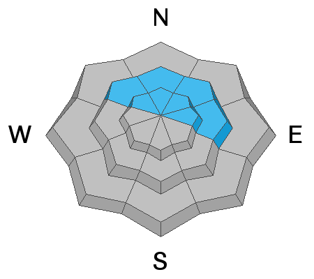
The avalanche danger is CONSIDERABLE on upper elevation slopes facing northwest, north, and east. Avalanches may break down 2-8' deep (possibly deeper) and hundreds of feet wide. Natural avalanches are possible, and human-triggered avalanches are likely. My advice is to continue avoiding this terrain.
A MODERATE avalanche danger exists on west and south-facing upper elevations as well as mid elevations facing northwest, north, and east. A LOW avalanche danger exists on low elevation slopes and mid elevation slopes without wind drifted snow.
Low
Moderate
Considerable
High
Extreme
Learn how to read the forecast here
Weather and Snow
Temperatures this morning are in the low to mid 20s F. Overnight, winds increased from the south, not a huge amount, but enough to likely transport snow. They are blowing 20-25 mph gusting 35 mph although they are blowing 48 mph gusting to 56 mph on Mt Ogden.
Today temperatures will generally rise to low 30s F, but lower elevation locations should have temperatures in the upper 30s F. High clouds will gradually increase through the day. Winds will increase some and continue blowing from the south and southwest.
Snowfall returns tomorrow late morning. Heavier snowfall arrives Wednesday morning to Thursday morning. This storm looks like it will have strong winds, increasing temperatures, and increasing snow densities.

Snow conditions and coverage are about as good as they get. Strong sunshine yesterday may have warmed the snow on south facing slopes in a few areas enough to have a slight crust this morning. Settled snow depths are generally just under 4 feet.
Recent Avalanches
No avalanches were reported yesterday; however, resorts have triggered some large avalanches as recently as Saturday on northerly facing slopes near 9000 ft. These have been up to 4 feet deep and 400 feet wide.
Ad
Avalanche Problem #1
Persistent Weak Layer
Type
Location
Likelihood
Size
Description
The situation is very simple - there is a persistent weak layer (PWL) of old, faceted snow near the ground with 3-4 feet of snow on top of it that can avalanche. Winds increased from the south and have likely been loading the slopes where this PWL exists.
This layer exists on north, and east-facing slopes where old snow lingered and weakened in November and was buried by December snowfall. This layer seems to be fairly widespread at upper elevations above 8,500 feet and more spotty at mid elevations. It doesn't exist on south and west facing slopes because it melted away in November, and December snowfall landed on bare ground on those slopes.
Since Christmas Eve, snowfall containing up to 6 inches of water has been added to the snowpack. We focus on water amounts because that tells us how much weight is added to the snowpack. For a slope the size of a football field, snow with 6 inches of water weighs 2,100,000 pounds. Imagine that amount of snow crashing downhill.

How will we know when this avalanche problem heals? That's a tough question to answer, and we mainly have to let the snowpack answer it. For now, avalanches are still happening and that's all I need to know. As we look into the future, it will heal, but I can't tell you when. We will be monitoring the snowpack and avalanche activity and keep you updated.
Avalanche Problem #2
Wind Drifted Snow
Type
Location
Likelihood
Size
Description
This morning, south winds increased some and have likely been forming fresh slabs of wind drifted snow. Even at 7700 feet, winds have increased. Yesterday, a regular observer near Ben Lomond Peak observed increased west winds moving snow at mid elevation ridgelines (see video below). These fresh wind slabs weren't reactive yesterday, but may be today.
For the snowpack, when the winds drift snow, it's the same as if snow is falling out of the sky. The snowpack doesn't care where the snow comes from, it feels the added weight. So, on northerly facing slopes, these winds have added snow and weight and stress to the avalanche problem listed above.
While these winds have mostly formed drifts on northerly facing slopes, they can load any slope because winds swirl and change direction as they pass through the mountains. What to do? Avoid any steep west, north, or east facing terrain that has avalanche problem listed above. If riding south facing avalanche terrain, look for evidence of fresh drifts and wind slabs that look wavy, rounded, smooth, and pillowly and avoid them as well. Fortunatley, those fresh drifts are easy to see and go around.
(video - B. Brandt)
General Announcements
Who's up for some free avalanche training? Get a refresher, become better prepared for an upcoming avalanche class, or just boost your skills. Go to https://learn.kbyg.org/ and scroll down to Step 2 for a series of interactive online avalanche courses produced by the UAC.
This information does not apply to developed ski areas or highways where avalanche control is normally done. This forecast is from the U.S.D.A. Forest Service, which is solely responsible for its content. This forecast describes general avalanche conditions and local variations always occur.