Donate to Our Spring Campaign or Bid on our Spring Auction to Support Forecasting

Forecast for the Ogden Area Mountains

Dave Kelly
Issued by Dave Kelly on
Sunday morning, April 2, 2023
The avalanche danger is CONSIDERABLE in upper elevation terrain due to multiple days of strong winds that have transported recent storm snow into stiff drifts on the leeward side of the mountains. Avalanches may break 1-3' feet deep and 100-200' feet wide. The avalanche danger is MODERATE elsewhere.

Give cornices a wide berth and avoid wind-loaded slopes. Soft snow and good turns can be found on slopes under 30 degrees and out of the wind zone.
Low
Moderate
Considerable
High
Extreme
Learn how to read the forecast here
Weather and Snow
This morning under overcast skies it is snowing lightly, trailhead temperatures have dropped from yesterday's high of 40˚F and are in the low 30's ˚F. Ridgetop temperatures are in the mid 20's ˚F. Winds are blowing south-southwest in the low teen's gusting to the 30's MPH at the 8,000' ridgelines and west-southwest in the 20's gusting to the low 30's MPH at the 9,000' ridgelines. Since it started snowing a few hours ago some locaitons are reporting 2-3" of new snow.

For today, skies will be mostly to partly cloudy before a storm begins moving in this evening. Temperatures will be 40-44˚F, and winds will gradually increase from a southwest direction 15 gusting to 25 MPH at the 8,000' ridgelines and 30 gusting to 50 MPH at the 9,000' ridgelines. Some mountain locations could see an additional 2-4" of snow throughout the day.

Yesterday, the snow surface at lower elevations out of the wind zone took heat and you may find a light melt-freeze crust around the compass up to 8,000' and on the sunny side of things. There was a brief window when green-housing occurred midday yesterday.

The National Weather Service has issued a Winter Storm Watch from noon today- Tuesday April 4th. They are forecasting 20 to 30" of snow with locally higher amounts up to 4' in the Cottonwoods and Davis County mountains.
Recent Avalanches
This season's continued onslaught of storms has created an all you can eat buffet of avalanche conditions. Over the last few days, we have had reports of new snow, wind-drifted snow, wet loose, and glide avalanches. Large avalanches were reported on the North Ogden Divide HERE.

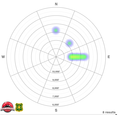
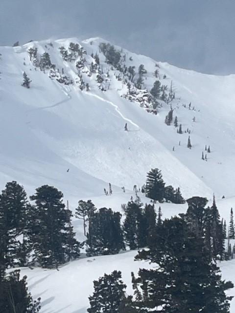
Heat map showing backcountry avalanches that occurred on April 1 and were reported to the UAC from the Salt Lake, Ogden, and Provo area mountains.
Check out all observations HERE.
Ad
Avalanche Problem #1
Wind Drifted Snow
Type
Location
Likelihood
Size
Description
Continued moderate to strong south/southwest winds have moved all of last week's soft snow onto the leeward side of the mountains and you will find sensitive slabs of wind-drifted snow primarily on north-east facing slopes. Triggering an avalanche involving a recent or fresh wind drift may step down into one of the more deeply-buried interfaces. These avalanches may be much deeper in higher elevation terrain where we could see an outlier avalanche like the natural cycle that occurred in the Provo area mountains a couple of days ago.

This danger is most pronounced at the highest elevations above treeline but could be found at treeline on north-east facing slopes.

The cornices are HUGE and recent winds have only added to their size and sensitivity. Cornices have been breaking off naturally, triggering avalanches onto the slopes below. Travel well-back from corniced ridgelines and do not travel below a slope with cornices above.
Photo of a natural avalanche in the Snowbasin Periphery terrain (Photo Snowbasin Ski Patrol)
Photo of wind-drifting on Cutler Ridge (Photo Shane M.)
Avalanche Problem #2
Wet Snow
Type
Location
Likelihood
Size
Description
It won't take a lot of daytime warming or mid-day sun to bring about a wet-loose cycle on steep lower elevation aspects. The wild card will be how much the wind cools the snow surface at these elevations.

Be aware of roof slides today. Any mountain homes with snow on the roof will be suspect as the sun warms things up. Stay out from underneath roofs and check to make sure children playing and adults shoveling are clear of roof lines once the sun heats up.
General Announcements
This information does not apply to developed ski areas or highways where avalanche control is normally done. This forecast is from the U.S.D.A. Forest Service, which is solely responsible for its content. This forecast describes general avalanche conditions and local variations always occur.