Donate to Our Spring Campaign or Bid on our Spring Auction to Support Forecasting

Forecast for the Ogden Area Mountains

Dave Kelly
Issued by Dave Kelly on
Saturday morning, April 1, 2023
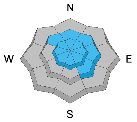
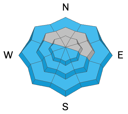
The avalanche danger is HIGH at mid and upper elevations due to recent heavy snowfall, wind transported snow, and today's forecasted sun and clear skies. Avalanches may break 2-3' feet deep and 100-200' feet wide. The avalanche danger is CONSIDERABLE at the lowest elevations.

Give yesterday's storm time to settle out and stick to terrain under 30 degrees. Travel in and below avalanche terrain is not recommended.
Low
Moderate
Considerable
High
Extreme
Learn how to read the forecast here
Avalanche Warning
An avalanche warning is in effect from now until 6am on Sunday April 2, 2023 for the Mountains of Northern Utah.
Recent heavy snowfall and strong winds have created dangerous avalanche conditions in the backcountry. Human triggered and avalanches are likely. Travel in avalanche terrain is not recommended. Stay off of and out from under slopes steeper than 30 degrees.
Weather and Snow
This morning under partly cloudy skies, trailhead temperatures are in the mid 20's ˚F and ridgetop temperatures are in the high-teens ˚F. Winds are blowing west-southwest in the teen's gusting to the 20's MPH at the 8,000' ridgelines and southwest in the 30's gusting to the 40's at the 9,000' ridgelines. Mountain locations reported a trace of additional snow overnight.
For today, skies will be clear with clouds building later this afternoon. Temperatures will be spring like rising to 38-42˚F, and winds will gradually increase from a southwest direction 25 gusting to 35 at the 8,000' ridgelines and 35 gusting to 55 MPH at the 9,000' ridgelines. No precipitation is expected today.

Storm Totals/Snow Water Equivalent since Wednesday and Snow Depths
  • Ogden Area Mountains 26-38" snow/ 2.9-3.8" water with snow depths from 137-222"

The National Weather Service has issued a Winter Storm Watch from Sunday April 2- Tuesday April 4th with another 20 to 30" of snow with locally higher amounts up to 4' in the Davis County mountains.
Recent Avalanches
Yesterday backcountry riders and mountain operations reported sensitive avalanche conditions with large avalanches and impressive powder clouds. There were delays and closures due to avalanches on highways throughout the Wasatch including low elevation roads affected in the Ogden Area Mountains.

Recent snowpits showed us a handful of weak layers now buried 3-5' deep, and today is not a day I would want to play the "am I good or am I lucky game".
Photo of avalanche off of south and west facing Ben Lomond (Photo S. Opheikens)
Check out all observations HERE.
Ad
Avalanche Problem #1
New Snow
Type
Location
Likelihood
Size
Description
Heavy snowfall over the last week has created sensitive soft slabs of storm snow. Avalanches may fail within today's storm snow or on one of many deeply-buried interfaces within the storm snow. Avalanches failed down into these deeply-buried layers even prior to this last storm in locations such as Two Dogs, Ant Knolls, Rainbow Peak, and Mill B South. These are the size of avalanches you are likely to see today in the Ogden Area Mountains.

Storms have been and continue to be stacked and brief breaks of sun have created a crust/facet sandwich in isolated areas that could cause deep and wide avalanches. This is a lot of snow and this makes for complex layering in the top layers of the snowpack. UAC director Mark Staples discusses snowpack layering in Farmington Canyon just south of the Ogden Area Mountains in this video.
Avalanche Problem #2
Wind Drifted Snow
Type
Location
Likelihood
Size
Description
Moderate to strong south/southwest winds have an abundance of soft snow to transport and you will find sensitive slabs of wind-drifted snow at the upper elevations as well as some mid elevation slopes. Triggering an avalanche involving a recent or fresh wind drift may step down into one of the deeply-buried interfaces.

The cornices are immense and recent winds have only added to their size and sensitivity. Cornices may break off naturally, triggering an avalanche onto the slope below. Travel well-back from corniced ridgelines and do not travel below a slope with cornices above.
Avalanche Problem #3
Wet Snow
Type
Location
Likelihood
Size
Description
Today's heating will INCREASE the avalanche danger on solar aspects. Steep rocky gully features on the sunny side are of concern. Expect to see wet loose avalanches with an off chance of seeing wet slab avalanches that may run into lower elevation terrain. Snow doesn't like rapid change and today is the first day that this new snow will see direct sun and increased temperatures. This wet snow hazard can be avoided by staying off of sun-heated slopes during the warmest hours of the day. Roller-balls and pinwheels are signs that it is time to find another slope.

Any mountain homes with snow on the roof will be suspect as the sun warms things up. Stay away from roof lines and check to make sure children playing and adults shoveling are clear of roof lines once the sun heats up.
General Announcements
This information does not apply to developed ski areas or highways where avalanche control is normally done. This forecast is from the U.S.D.A. Forest Service, which is solely responsible for its content. This forecast describes general avalanche conditions and local variations always occur.