To help you safely enjoy the backcountry, the UAC team is constantly evaluating and implementing new programs and technologies.
Donate to the Spring Campaign to help our team implement innovative tools and better provide you with the information you rely on. Thank You!
Overview: The storms continue as quick moving trough of low pressure moves over the area late tonight with strong convection that could cause some lightning. It will bring snowfall late this afternoon and this evening. There is a break Thursday before a warm and wet storm arrives late Friday and lasts through the weekend. According to NWS forecasters "this storm will be fed by a warmer inland penetrating atmospheric river with denser snow and higher snow levels." Another brief break is possible Monday before another storm may come on Tuesday. NOTE, if you're looking for a day with some sunshine to get out, consider planning on tomorrow (Thursday) as the weather will be a wild ride through the weekend (Read more about it from Jim Steenburgh
HERE)
Temperatures this morning at most elevations are in the upper teenss F. Today they should warm into the upper 20s F (a bit cooler up high and near freezing down low)
Winds from the south and southwest are mostly light with gusts on Mt Ogden only reaching 16 mph. They shouldn't do much until this afternoon ahead of the approaching trough when southwest winds could become quite gusty reaching 40-60 mph.
Snowfall yesterday was limited to some snowflakes dancing in the air without any accumulation. Light snowfall should start around midday with high snowfall rates sometime around the end of today and this evening when some lightning will be possible. By tomorrow morning there should be 2-5" of new snow with higher amounts of 11" in some areas.
Snow conditions are fantastic with great powder riding. Southerly facing slopes received just enough sunshine yesterday to have a soft crust on them this morning. Total snow depths are 8-11' in the Ogden area mountains where up to 7' is at some low elevation locations (Ogden Valley residents know all too well how much shoveling they've done this winter :)
Recent avalanche activity in the Ogden area mountains has been limited. Much more activity has happened near SLC and Provo and is worth paying attention to. Many of these slides broke on SE and E facing slopes on top of a sun crust that formed last Thursday. See all the recent slides
HERE.
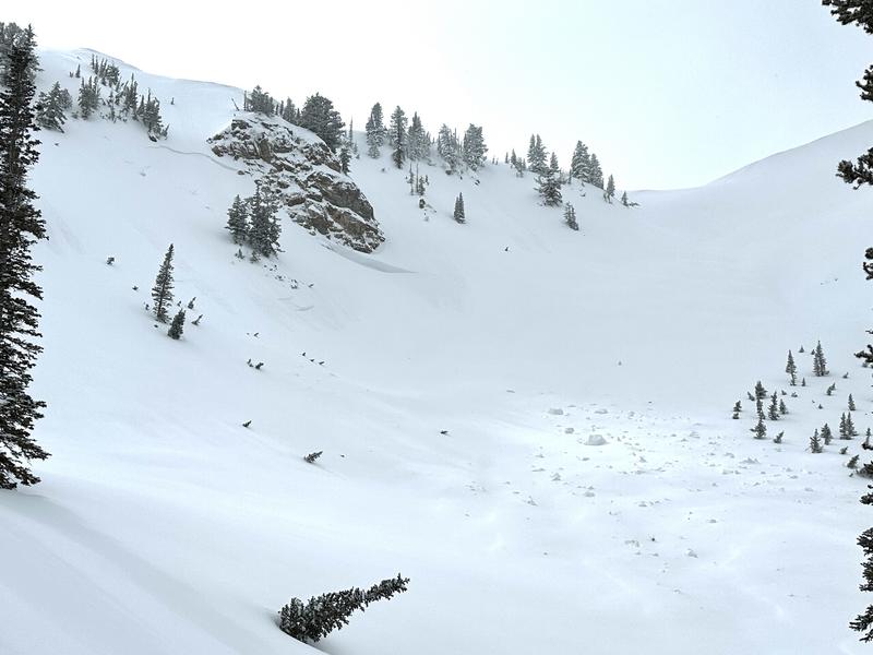
One regular observer
on Monday in Farmington Canyon spotted a slab of wind-drifted snow (photo) that had been triggered by a falling cornice but otherwise found a strong stable snowpack in his snowpits.