Donate to Our Spring Campaign or Bid on our Spring Auction to Support Forecasting

Forecast for the Ogden Area Mountains

Drew Hardesty
Issued by Drew Hardesty on
Saturday morning, February 6, 2021
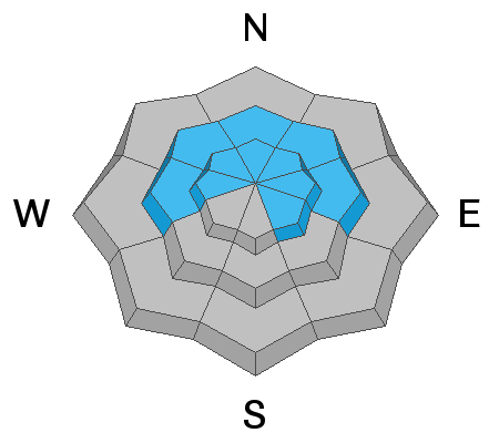
Areas of HIGH DANGER exist this morning in steep upper elevation terrain. This danger is most pronounced on north through southeast facing slopes. A CONSIDERABLE danger exists at the mid-elevations and this is where we may see a few close calls today. Avalanches may be up to 5' deep and over several-hundred feet wide. Remember that avalanches can be triggered from a distance.
The Good News: safe and surfy riding conditions can be found on low angle terrain of all aspects with no overhead hazard.

IF YOU'RE HEADED OUT OF BOUNDS AT A SKI AREA, YOU ARE STEPPING INTO DANGEROUS AVALANCHE CONDITIONS
Low
Moderate
Considerable
High
Extreme
Learn how to read the forecast here
Special Announcements
With great sadness, the Utah Avalanche Center reports that a 57-year old skier, Kurt Damschroder of Park City, was killed Saturday, January 30 in a backcountry avalanche off of Square Top Peak, located on the Park City Ridgeline. The final accident report can be found HERE. Our thoughts go out to those affected by this tragic accident, especially the family and friends of Kurt.
Since February 1, there have been nine other avalanche fatalities in the US.
Weather and Snow
Skies are mostly cloudy. Mountain temperatures are generally in the teens to low 20s.
Winds are strong from the northwest along the upper elevations with gusts to 30 well off the ridgelines.
Storm totals are 10-12" and riding conditions are excellent.
For today, skies will trend partly cloudy with mountain temperatures rising to the low to mid-20s. Expect no mercy from the northwest winds; they're forecast to increase in speed this afternoon.
The Outlook: A weak system may produce a flurry or two in the Logan and Ogden mounains this afternoon.
With a high amplitude ridge to the West, we'll remain under a cool, breezy northwest flow through mid-week.
Recent Avalanches
We didn't hear of any avalanches in the backcountry yesterday but I suspect a few wind slabs ran naturally in heavily wind loaded areas.
Ad
Avalanche Problem #1
Persistent Weak Layer
Type
Location
Likelihood
Size
Description
We may see a few avalanches to the ground. These may be explosive triggered, natural, or human triggered. The heavy snowfall and sustained winds may be too much for some of our northerly terrain with a creaky snowpack; particularly areas that have previously avalanched to near the ground this year. Any fresh wind slab or new snow avalanche may step down into this older layering of weak snow.
Avalanche Problem #2
Wind Drifted Snow
Type
Location
Likelihood
Size
Description
Strong winds will continue to move snow into wind drifts that may be increasingly stubborn and less reactive as the day wears on. The wind drift may be well off the ridgelines, cross-loaded across the landscape, and may release on not the first but perhaps second or third rider across the slope. Cracking and collapsing may or may not be evident.
General Announcements
Please visit this website with information about Responsible Winter Recreation by the Utah Office of Outdoor Recreation.

This information does not apply to developed ski areas or highways where avalanche control is normally done. This forecast is from the U.S.D.A. Forest Service, which is solely responsible for its content. This forecast describes general avalanche conditions and local variations always occur.