Donate to Our Spring Campaign or Bid on our Spring Auction to Support Forecasting

Forecast for the Ogden Area Mountains

Greg Gagne
Issued by Greg Gagne on
Friday morning, February 5, 2021
The avalanche danger is HIGH at the upper elevations, CONSIDERABLE at mid-elevations and MODERATE at low elevations. On upper elevation aspects facing west through north and southeast, avalanches may break down into deeply-buried weak snow and be up to 5' deep and over several-hundred feet wide.
Heavy snowfall and strong winds will create a rising avalanche danger today. Be prepared for rapidly-changing avalanche conditions.
Low
Moderate
Considerable
High
Extreme
Learn how to read the forecast here
Special Announcements
With great sadness, the Utah Avalanche Center reports that a 57-year old skier, Kurt Damschroder of Park City, was killed Saturday, January 30 in a backcountry avalanche off of Square Top Peak, located on the Park City Ridgeline. The final accident report can be found HERE. Our thoughts go out to those affected by this tragic accident, especially the family and friends of Kurt.
Since February 1, there have been nine other avalanche fatalities in the US.
Weather and Snow
The Wednesday/Thursday storm delivered 6-8" of snow to the Ogden mountains and another cold and windy storm is forecasted for today with heavy snowfall and strong winds. As of 6 am, temperatures range through teens with strong winds from the west/southwestwest. At mid- elevations winds are averaging in the 20's mph with gusts in the 30's mph. Along upper-elevation ridgelines winds are gusting in the 40's mph. Atop Mount Ogden gusts are in the 50's mph.
Snowfall will begin this morning and continue throughout the day with periods of heavy snow likely. By late afternoon 8-12" of snow are possible, with possibly higher amounts around Ben Lomond and the southern Bear River Range. The west/northwest winds will continue to be strong through much of the day, averaging in the 20's and 30's mph at the mid-elevations and 40's at the upper elevations. Very strong gusts of 40-50 mph can be expected at the mid and upper elevations with gusts exceeding 50 mph on Mount Ogden. Temperatures will be in the low 20's F.
Snowfall should continue overnight and into Saturday morning, with an additional 2-4" possible.
Recent Avalanches
Other than sluffing in the new low-density snow, no backcountry avalanches were reported on Thursday.
We did receive several excellent observations this past week. On Thursday, Drew visited Ben Lomond and noted pre-frontal warm temperatures and rain on Wednesday left a crust underneath the recent storm snow up to about 8,000'.
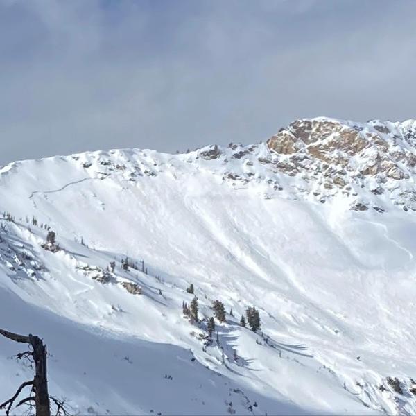
The biggest avalanche we heard of this week was a large natural on Willard Peak [Bill Brandt photo]
Ad
Avalanche Problem #1
Persistent Weak Layer
Type
Location
Likelihood
Size
Description
Various layers of weak, faceted snow and depth hoar are present on mid and upper elevation aspects facing west through north and southeast. Today's rapid loading of new snow and wind-drifted snow may be enough to again overload these deeply-buried weaknesses, with avalanches breaking down over 3' deep and over several hundred feet wide. You may not get any warnings - such as collapsing or cracking - of these instabilities until you hit the right spot on the slope and trigger a large, dangerous, and likely unsurvivable avalanche.
The best advice is to avoid being on or underneath slopes steeper than 30° on these aspects at the mid and upper elevations where this persistent weak layer is present.
AVALANCHE TREND: INCREASING
Avalanche Problem #2
Wind Drifted Snow
Type
Location
Likelihood
Size
Description
Strong winds will drift snow at the mid and upper elevations. Although the winds are from the west/northwest, these strong winds can work around terrain features and drift snow on any aspect. These fresh drifts will be on top of low-density snow that fell overnight Wednesday and into Thursday and may be sensitive. As mentioned under the persistent weak layer problem, these drifts may also be enough of a load to trigger larger avalanches failing in the deeply-buried weak faceted snow.
Cornices may also quickly develop today and be quite sensitive. Stay well-back from corniced ridges.
AVALANCHE TREND: INCREASING
Avalanche Problem #3
New Snow
Type
Location
Likelihood
Size
Description
Periods of heavy snow are likely today with sluffing in the new snow expected on steeper slopes. Sensitive slabs of storm snow are also possible, especially during any period of heavy precipitation-intensity. Just as with any fresh wind drifts, this rapid load of new snow may be enough to trigger larger avalanches failing in deeply-buried persistent weak layers.
AVALANCHE TREND: INCREASING
General Announcements
Please visit this website with information about Responsible Winter Recreation by the Utah Office of Outdoor Recreation.

This information does not apply to developed ski areas or highways where avalanche control is normally done. This forecast is from the U.S.D.A. Forest Service, which is solely responsible for its content. This forecast describes general avalanche conditions and local variations always occur.