Donate to Our Spring Campaign or Bid on our Spring Auction to Support Forecasting

Forecast for the Ogden Area Mountains

Drew Hardesty
Issued by Drew Hardesty on
Sunday morning, January 15, 2023
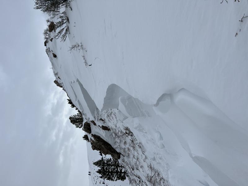
The avalanche danger will rise to CONSIDERABLE today in areas that receive the most snow and wind. If you are heading into the upper elevations, human triggered avalanches will be likely. Cautious route-finding and conservative decision-making will be essential.
Low
Moderate
Considerable
High
Extreme
Learn how to read the forecast here
Weather and Snow
Another Pacific storm. Another powder day.
Mountain temperatures are in the mid to upper 20s. Winds are from the southeast, blowing 15-20mph with gust to 30mph. As of 5am, most areas have picked up 4-6".
Riding conditions will only keep improving as we should see an additional 4-8" of lowering density snow through early evening. Winds will move from the southeast to the northwest and be light to moderate. Temps will be in the 20s.

Another storm system arrives later Monday into Tuesday that should provide an additional 6-10" of snow. A weaker storm follows on Friday.
Recent Avalanches
No new avalanches were reported from the backcountry yesterday although one observer found a very large avalanche from the mid-week cycle just north and west of Thurston Peak. Photo Tyler Call
Ad
Avalanche Problem #1
New Snow
Type
Location
Likelihood
Size
Description
You will be able to trigger soft slabs and loose dry sluffs in the new snow today, particularly during periods of higher snowfall rates. Ski cuts will be effective mitigation tools for experienced practitioners. Watch for cracking within the new snow for signs of instability in the mid and upper elevations.
IF you get caught in an avalanche today, where will you end up?
Avalanche Problem #2
Wind Drifted Snow
Type
Location
Likelihood
Size
Description
Today, you'll find shallow sensitive soft slabs of wind driven snow, particularly in the upper elevations. Drifts will be more prevalent on west to north to easterly facing aspects. These soft slabs may crack out upon approach.
Continue to give the growing cornices a wide berth.
Avalanche Problem #3
Persistent Weak Layer
Type
Location
Likelihood
Size
Description
The mid week storm produced many large hard slab natural avalanches failing on our persistent weak layer of facets (PWL) from mid-November. Many of these avalanches were 4-6' deep....and upwards of 10' deep in heavily wind loaded terrain. The PWL is so deeply buried that it would require a significant trigger (large cornice, multiple people on a slope, powerful storm) to avalanche. For skiers and riders, it may require finding a thinner snowpack area (4' deep or less) to trigger one of these avalanches.
The trend is toward stabilization and I suspect we will remove this as an avalanche problem soon.
General Announcements
This information does not apply to developed ski areas or highways where avalanche control is normally done. This forecast is from the U.S.D.A. Forest Service, which is solely responsible for its content. This forecast describes general avalanche conditions and local variations always occur.