Donate to Our Spring Campaign or Bid on our Spring Auction to Support Forecasting

Forecast for the Skyline Area Mountains

Brett Kobernik
Issued by Brett Kobernik on
Thursday morning, January 12, 2023
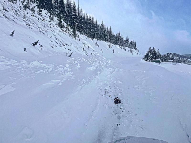
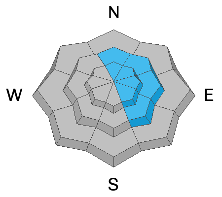
The danger rating is CONSIDERABLE on upper elevation northwest through southeast facing steep slopes.
Recent heavy snowfall and strong wind created natural avalanches over the last few days. This instability may be lingering on wind loaded slopes today.
Cornices will still be sensitive today and are likely to break off if provoked.
Today's sun will probably heat and make the more southerly steep slopes prone to natural wet loose avalanches. Avoid steep terrain if you notice overly damp snow and rollerballs forming.
Low
Moderate
Considerable
High
Extreme
Learn how to read the forecast here
Special Announcements
State Road 31 will be closed from the top of Fairview Canyon through Huntington Canyon for snow removal today. The closure is at the intersection of State Road 264 through mile marker 33 in Huntington Canyon. The north Skyline Drive trailhead is accessible as well as State Road 264.
Weather and Snow
Current Conditions: The Skyline picked up a few more inches of snow on Wednesday. The northern end of the Skyline has picked up over 2 feet since Monday and the central and southern end picked up about a foot. Strong wind from the west has slowed down now. Temperatures are in the upper teens this morning.
Mountain Weather: It'll be a spectacular day in the mountains with sun and temperatures getting into the upper 20s. Wind will be light from the west southwest. Friday looks similar with slightly warmer temperatures, a few more clouds and a slight bump in southerly wind speeds later in the afternoon. More clouds move in Saturday and another storm will start Saturday night into Sunday bringing another good shot of snow. More storms are anticipated next week.
Recent Avalanches
There was a natural avalanche that released early Wednesday morning near the dam at Electric Lake. It was on a very steep road cut that is susceptible to wind loading. It broke 4 feet deep and the debris blocked the highway.
Ad
Avalanche Problem #1
Wind Drifted Snow
Type
Location
Likelihood
Size
Description
The strong wind drifted quite a bit of snow during the last storm. Enough to cause natural avalanches within the new snow. Often, these new snow instabilities settle and stabilize rapidly. However, things may still be unstable today. It's been less than 24 hours since the storm let up. I'd give the snowpack a day before getting onto steeper terrain.
Cornices will be quite large in places and should be avoided today. Many of these will break if provoked by a person. These will also stabilize over time.
Avalanche Problem #2
Persistent Weak Layer
Type
Location
Likelihood
Size
Description
It is unknown if there was any significant avalanche activity that broke into the old November Persistent Weak Layer. During fieldwork over the last few days, I did not come across anything alarming. With better visibility today, we should be able to get a look around and see if any natural avalanches broke deep. Since there are still questions about the deeply buried faceted layer from November, I would continue to avoid the steeper northerly facing terrain today. My hope is that we don't find any avalanches that broke deep. If this is the case, we can probably dismiss the old weak layer for the time being.
Avalanche Problem #3
Wet Snow
Type
Location
Likelihood
Size
Description
With sun and warm temperatures expected today, I'm guessing we'll see some loose wet natural avalanches on the steep southerly facing slopes. If you notice that the snow is really wet and you're seeing rollerballs or pinwheels, avoid being on or below steep slopes. Stay out of deep ravines and gullies where the snow is becoming wet.
General Announcements
This forecast is from the U.S.D.A. Forest Service, which is solely responsible for its content. This forecast describes general avalanche conditions and local variations always occur.