Donate to Our Spring Campaign or Bid on our Spring Auction to Support Forecasting

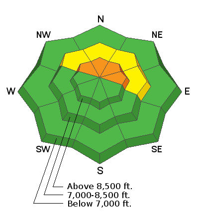
Forecast for the Ogden Area Mountains

Trent Meisenheimer
Issued by Trent Meisenheimer on
Tuesday morning, December 21, 2021
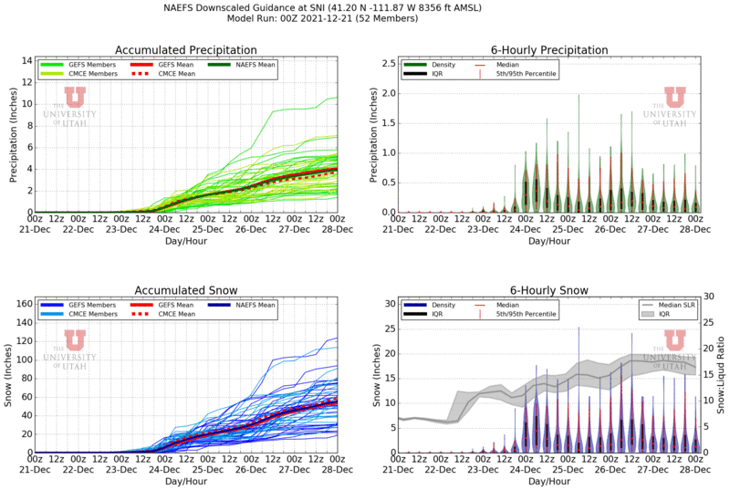
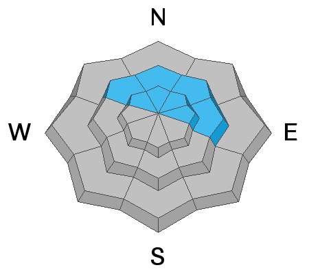
Areas of CONSIDERABLE avalanche danger exist on northwest through easterly facing slopes at the upper elevations in Ogden.
Avalanches may break down 2' deep and propagate over a hundred feet wide. Cracking and collapsing are signs of instability. My advice is to stay on low-angle slopes with nothing steep above.
Remember: if you're headed out of bounds at a ski area you are entering Considerable avalanche danger.
Low
Moderate
Considerable
High
Extreme
Learn how to read the forecast here
Special Announcements
HEADS UP: With lots of wind & snow in the forecast, the avalanche danger will be on the rise starting Thursday and will continue to be dangerous through the holiday break. Please share the word with friends, family, and riding partners that conditions will continue to be dangerous and deadly here in Northern Utah, especially as the new snow stacks up. Be careful, friends.
Weather and Snow
High pressure will lead to another beautiful day in the mountains with calm winds and warm temperatures. Currently, the mountain temperatures hover in the mid 20's °F at the mid and upper elevations. Winds are blowing from the west-southwest at speeds of 15-20 mph, with the occasional gust into the upper 20's across the skyline.
Buckle up! It's going to get wild here in Northern Utah. The extended weather forecast is nothing but storms for the foreseeable future. All this weather begins Wednesday night and easily lasts into next week with inches of water and feet of snow. YES, that picture below shows a mean of the ensemble members at 40-50" of snow with 4.0" of water. I wouldn't hold your breath for those numbers, but it's fun to imagine, and it's possible. I usually don't get this excited, but it's hard not to.
Recent Avalanches
No new avalanches were reported from the backcountry yesterday.
Ad
Avalanche Problem #1
Persistent Weak Layer
Type
Location
Likelihood
Size
Description
A poor snowpack structure exists on shady aspects at the mid and upper elevations. Forecaster Greg Gagne toured near Powder Mountain on Saturday and experienced long shooting cracks and rolling thunder collapses. His video is below. His full report is HERE. At this point, the best strategy will be to avoid steep terrain that harbors this weak unstable snow structure. Remember that you can trigger these avalanches from a distance.
General Announcements
Who's up for some free avalanche training? Get a refresher, become better prepared for an upcoming avalanche class, or just boost your skills. Go to https://learn.kbyg.org/ and scroll down to Step 2 for a series of interactive online avalanche courses produced by the UAC.
This information does not apply to developed ski areas or highways where avalanche control is normally done. This forecast is from the U.S.D.A. Forest Service, which is solely responsible for its content. This forecast describes general avalanche conditions and local variations always occur.