Donate to Our Spring Campaign or Bid on our Spring Auction to Support Forecasting

Forecast for the Ogden Area Mountains

Drew Hardesty
Issued by Drew Hardesty on
Saturday morning, December 18, 2021
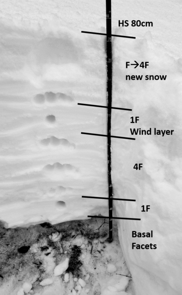
Areas of CONSIDERABLE avalanche danger exist on northwest through easterly facing slopes above about 8000'. Avalanches may break down 2' deep and propagate over a hundred feet wide. Pockety wind drifts may be found in the upper elevation bands and are to be avoided.
Low
Moderate
Considerable
High
Extreme
Learn how to read the forecast here
Weather and Snow
Skies are clear.
Temperatures are in the teens. Winds are generally light from the west.
An additional 3-4" of low density snow fell yesterday, pushing storm totals to 20-30" since late Tuesday.
For today, we'll see clear skies, light wind and mountain temperatures in the 20s.
We'll have a bit of a break before the next series of storms barrel through mid/late week.
Recent Avalanches
Ski area control teams yesterday remotely triggered some wind slabs as well as loose new snow avalanches.
Ad
Avalanche Problem #1
Persistent Weak Layer
Type
Location
Likelihood
Size
Description
A poor snowpack structure exists on shady aspects above roughly 7500-8000'. Yesterday, backcountry observers noted cracking and collapsing associated with this layering but did not trigger any avalanches. Derek DeBruin's snowpit profile is below. At this point, the best strategy will be to avoid steep terrain that harbors this weak unstable snow structure. Remember that you can trigger these avalanches from a distance.
General Announcements

This information does not apply to developed ski areas or highways where avalanche control is normally done. This forecast is from the U.S.D.A. Forest Service, which is solely responsible for its content. This forecast describes general avalanche conditions and local variations always occur.