Donate to Our Spring Campaign or Bid on our Spring Auction to Support Forecasting

Forecast for the Ogden Area Mountains

Nikki Champion
Issued by Nikki Champion on
Saturday morning, March 6, 2021
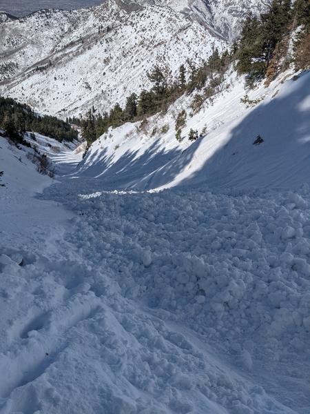
The avalanche danger will rise to MODERATE on all elevations and aspects. As the day heats up wet loose avalanches will become possible on all south, east, west-facing slopes, as well up low and mid-elevation north-facing slopes. On upper elevation, northerly facing slopes with lingering dry snow, triggering a shallow slab of wind drifted snow remains possible.
Continue to maintain safe travel habits; this means exposing one person at a time to avalanche terrain, having someone watch them from a safe location, and not traveling above or below other parties.
Low
Moderate
Considerable
High
Extreme
Learn how to read the forecast here
Special Announcements
The UAC staff has published a blog with answers to the numerous questions we received but were not able to answer during the Q & A session for the online meeting regarding the Wilson Glades February, 6 accident.
Weather and Snow
This morning, skies are clear and temperatures range from the low 40s F at trailheads to mid 30s F at upper ridgelines. The southerly winds have increased overnight, averaging 15-25 mph and gusting up to 55 at upper elevations. The transition from winter to spring came quickly.
For today, expect more spring weather with clear skies and warm temperatures. Temperatures will rise well into the 30s and even low 40s F. Southerly winds will increase before a weak cold front moves in this afternoon. Expect the Southwesterly winds to average 20-35 mph with gusts up to 50 mph at the highest ridgelines. Warm temperatures will continue Sunday and Monday, with promising signs for a return to unsettled weather by perhaps Tuesday.

Our Week in Review - where we highlight significant avalanche and weather events from the past week - has been published.
Recent Avalanches
More minor wet-loose activity was noted on Friday. Reports of other wet activity from earlier in the week continues to roll in, one avalanche, in the Banana Chute was reported from Thursday. This avalanche slid up to 1000' in vertical. With increased temperatures and sun, more avalanches in confined terrain features like the Banana Chute are likely.
Photo of the wet activity in the Banana Chute. Photo: Erick C.
As always, you can find more details in the Observations and Avalanches tab above and locations of these areas HERE
Ad
Avalanche Problem #1
Wet Snow
Type
Location
Likelihood
Size
Description
Today's strong sunshine, warm temperatures, and lack of a solid overnight refreeze will cause the snow to get wet. This wet snow will produce small, loose wet avalanches. A few could be bigger if they entrain more snow as they roll downhill.
Slopes with exposed cliffs and rock bands or gullies where the sunshine is concentrated will be the most likely places to see loose wet avalanches. The most dangerous locations will be in confined gullies this afternoon when these slides can happen on their own and hit you from above.
Look for rollerballs and pinwheels rolling downhill and getting bigger as a sign that wet loose avalanches could start occurring.
In any upper elevation, northerly terrain features that have remained at all dry the increased southerly winds may have transported some lingering dry snow and created small pockets of recent-wind drifted snow. Avoid terrain features with obvious signs of wind-drifted snow.

Evaluate snow and weather conditions as you travel and update your own forecast based on what you are observing.
Additional Information
What happened to the persistent weak layer near the ground? The layer still exists but it is mostly dormant, and we don't expect avalanches to happen on it until something changes in the weather. A major spring storm with feet of new snow could awaken this layer. It also may be a problem again on slopes that produced big avalanches following the series of storms that happened near Valentine's day in the middle of February.
General Announcements
Please visit this website with information about Responsible Winter Recreation by the Utah Office of Outdoor Recreation.

This information does not apply to developed ski areas or highways where avalanche control is normally done. This forecast is from the U.S.D.A. Forest Service, which is solely responsible for its content. This forecast describes general avalanche conditions and local variations always occur.