Donate to Our Spring Campaign or Bid on our Spring Auction to Support Forecasting

Forecast for the Ogden Area Mountains

Mark Staples
Issued by Mark Staples on
Tuesday morning, March 2, 2021
Today the avalanche danger is MODERATE. On southerly and west-facing slopes, wet avalanches of loose snow will become possible as the snow surface warms and becomes wet. On east and northerly-facing slopes, soft slab avalanches of the new snow 18-24 inches deep are possible.
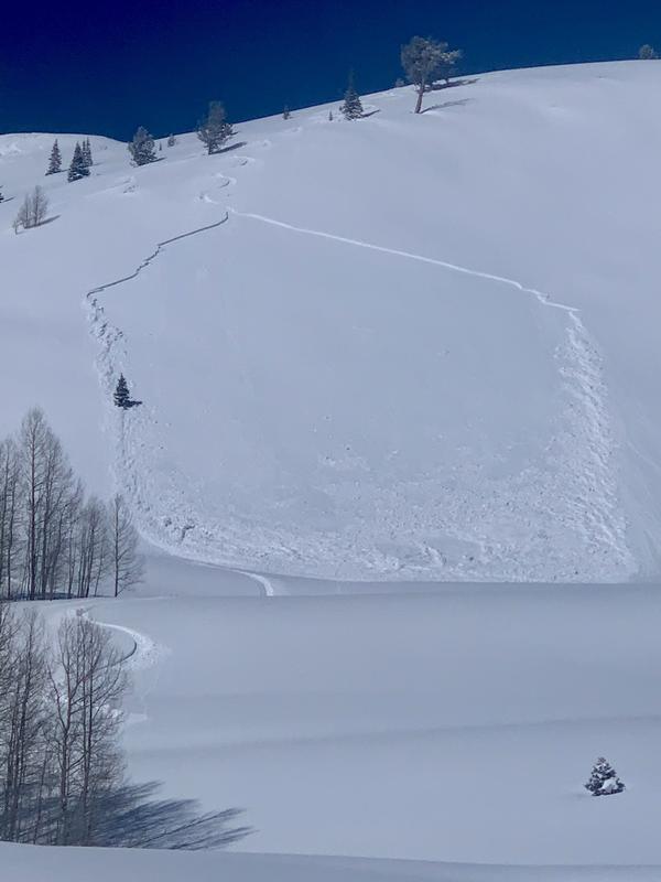
While unlikely, there remains a chance of triggering a hard slab avalanche on deeply buried persistent weak layers. In many places with a deep snowpack, that is almost impossible while it remains a slight possibility in areas with a thinner snowpack or on slopes that avalanched on this layer already.
Low
Moderate
Considerable
High
Extreme
Learn how to read the forecast here
Weather and Snow
Yesterday, winds were almost non-existent. High temperatures reached the low to mid 30s F, but it felt a lot warmer than that in the strong March sunshine. The snow surface became wet on east, south, and west-facing slopes while north-facing slopes maintained dry powder.
This morning, temperatures are mostly in upper 20s F on the west side of the Ogden Valley and low to mid 20s F on the east side of the valley. Winds shifted overnight, increased, and began blowing from the southwest. In most places, winds are blowing 15 mph gusting 25 mph. Above 9,000 ft, winds are blowing 20 mph and gusting 30 mph.
Today will be similar to yesterday with clear skies, strong sunshine, and light winds. A few high clouds should arrive this afternoon. Temperatures at low and mid-elevations should climb to the upper 30s F and may break into the low 40s F in some places. Southerly winds will blow 5-15 mph.
Snow depths in the Ogden area mountains range from 4 feet to over 6 feet deep. Snowfall on Friday/Saturday delivered 18-24 inches of snow. This powder has settled some but remains dry on north-facing slopes. After getting wet yesterday and refreezing overnight, there should be an ice crust on the snow surface on all other slopes.
Recent Avalanches
Under yesterday's strong sunshine and warm temperatures, the new snow became wet and there were some small wet avalanches of loose snow on east, south, and west aspects.
On Sunday in the central Wasatch Range near Salt Lake City, there were several soft slab avalanches of new snow roughly 10-18 inches deep and 40-125 feet wide worth paying attention to. Notable avalanches were Pinecone Ridge (photo below), Patsy Marly, Mineral Fork, and Murdock Peak.
Ad
Avalanche Problem #1
Wet Snow
Type
Location
Likelihood
Size
Description
Today's strong sunshine and warm temperatures will make the snow surface wet, but it will take a little longer than yesterday since an ice crust on the snow surface from last night's refreeze will have to melt first. As the day heats up, wet avalanches of loose snow will become possible. These wet snow avalanches will mainly involve the new snow that fell Friday/Saturday.
Pay attention to the snow becoming wet, then look for balls of snow rolling downhill and growing in size and occurring more frequently. Seeing these clues will tell you that loose wet avalanches may start happening. They tend to happen more near exposed rocks that absorb heat from the sun and help warm the snow faster.
Photo below shows these roller balls under exposed rocks (E. Romer)
Avalanche Problem #2
New Snow
Type
Location
Likelihood
Size
Description
Dry powder can still be found on north-facing slopes, but assess the snow in the upper 24 inches of the snowpack. Soft slab avalanches of the new snow are possible as seen in avalanche activity on Sunday noted above in the Recent Avalanches section. Although those slides happned further south, I suspect similar conditions exist in the Ogden area mountains.
On some slopes there may be some very small, weak facets under the new snow. I found small facets under the new snow on a south facing slope in the Uintas on Sunday and wouldn't be surprised to find them in a few other places today. What this means is that the new snow may have a good bond on some slopes while it will not have a good bond on others if these small facets exist. I don't expect this avalanche problem to be long lasting or widespread with this week's warm sunny weather.
Photo of an avalanche that happened in Mineral Fork on a west facing slope at 8,600 feet, 10 inches deep, 40 feet wide. (Landon M.)
Avalanche Problem #3
Persistent Weak Layer
Type
Location
Likelihood
Size
Description
Unfortunately, there is still a small chance that avalanches could break near the ground on a persistent weak layer of old faceted snow that caused many avalanches about two weeks ago. In many places in the upper Cottonwood Canyons, this weak layer is buried so deeply that it will be nearly impossible to trigger an avalanche on it. In places with a thinner snowpack (maybe less deep than a ski pole), a rider can still impact this layer, but it has had about 2 weeks to adjust to the load of heavy snow from the Valentine's storms and triggering avalanches on it is not impossible but unlikely.
One complicating factor - Many slopes produced big avalanches two weeks ago and will have maybe 2-3 feet of snow on top of the bed surface. We haven't heard of any avalanches repeating on these slopes, but I would be hesitant to totally trust them without doing a thorough assessment which could be difficult because the only way to examine the snowpack on these slopes will be to go into the avalanche starting zone.
When will this layer heal or go away? Good question. Read Daniel Turner's thoughts about it HERE.
General Announcements
Please visit this website with information about Responsible Winter Recreation by the Utah Office of Outdoor Recreation.

This information does not apply to developed ski areas or highways where avalanche control is normally done. This forecast is from the U.S.D.A. Forest Service, which is solely responsible for its content. This forecast describes general avalanche conditions and local variations always occur.