Donate to Our Spring Campaign or Bid on our Spring Auction to Support Forecasting

Forecast for the Ogden Area Mountains

Mark Staples
Issued by Mark Staples on
Wednesday morning, March 1, 2023
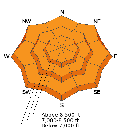
Today the avalanche danger is CONSIDERABLE. New snow, wind-blown snow, and more snow coming today are creating dangerous avalanche conditions.
What worries me the most is that the danger won't seem obvious, and avalanches may be a bit stubborn to trigger. Nonetheless, avalanches have the potential to be large, destructive, and far running.
Low
Moderate
Considerable
High
Extreme
Learn how to read the forecast here
Weather and Snow
Storm totals as of 0400 this morning:
  • Snowbasin area 28" snow (3.2" water)
  • Powder Mountain area 34" snow (3.07" water)
  • Ben Lomond area 25" snow (4.5-6" water - I'm not sure this is correct)
  • Monte Cristo area 20" snow (2.4" water)
Strong winds over the last two days have blown from both the SW and NW.

Temperatures this morning range from about 12°-21° F. Winds have eased and are averaging 11-19 mph gusting 25 mph from the SSW. Snowfall was just starting again at 0400 with a trace of snow.
Today temperatures will only warm to about 20° F. Overall winds will steadily drop through the day to barely a breath by the end of the day. Snowfall will ramp up this morning and 4-6 inches of new snow is possible by the end of the day.

Thursday will have a break in the active weather with "brief ridging", and we should see some sunshine (fresh pow and sun!). Temperatures remain cold through the weekend as cold air will continue to push south. A quick moving storm will bring more snow Friday. On Saturday the jet stream will begin to develop a strong zonal flow from the west over Utah and more snow should continue Sunday and into next week but the details are uncertain just yet.
"Winds were absolutely ripping from the west in exposed areas and carrying lots of snow" - from a group on Cutler Ridge yesterday
Recent Avalanches
Snow safety teams triggered some large slab avalanches mostly involving wind-drifted snow. I suspect some natural avalanches also occurred early yesterday morning during strong winds and intense snowfall but no one was able to observe the. One notable, triggered avalanche just south of Weber Canyon was 4-5' deep and 350' wide that failed on a layer of small, rounding facets.
(This layer of facets buried under last week's storm appears to be very isolated; however, it is more widespread in the Logan area possibly creating avalanches like one near Beaver Mtn yesterday)
Ad
Avalanche Problem #1
Wind Drifted Snow
Type
Location
Likelihood
Size
Description
Strong winds from both the NW and SW have had lots of snow to transport and form both soft and hard slabs of wind drifted snow. Winds this morning are steadily easing, and snowfall today will hide these thick wind slabs.
What is scary about this avalanche problem is that it will be camouflaged and a bit stubborn to trigger, but it can create big, deadly, destructive avalanches. I would avoid any wind-loaded slopes today which is most upper elevation terrain. Groups on Rodeo Ridge and Cutler Ridge yesterday reported widespread wind transport of snow.
Avalanche Problem #2
New Snow
Type
Location
Likelihood
Size
Description
The new snow yesterday was upside down which is a good recipe for avalanches. The slab is the denser snow on top and the weak layer is the softer snow underneath. It will be a tug-of-war game today as the previous snow tries to stabilize (the glue drying) and the new snowfall today adds additional weight and stress. With so much new snow and more coming today, I am just not ready to trust it with my life.

I don't think you'll see any signs of instability in the new snow today which will make decision making difficult, and you can likely get away with riding in avalanche terrain. Personally, I would give it a day and consider stepping out a little tomorrow. There are many layers within the new snow from the last two storms on which avalanches can break (see my video below from American Fork Canyon yesterday but the concepts are relevant). There is also softer layer (possibly faceted in isolated locations) buried under last week's snow that may break and produce a larger avalanche.
Additional Information
The lowest elevation band has some tricky conditions as we've seen avalanches in the foothills as low as 6,200'. There is more than enough snow in the lower elevation foothills that there is good riding to be had close to home. These three avalanches stand out in that they all occurred in low elevation easy to access terrain that you can see from highways and neighborhoods. Check out Craig's video discussing a low elevation avalanche in Browns Canyon HERE, Drew's video discussing an avalanche in the Salt Lake Foothills HERE, and JB's report from the Ogden Foothills HERE. These are the types of slides that can impact people with little knowledge of avalanche terrain. Please share this information with your friends who may not regularly read the avalanche report.
General Announcements
This information does not apply to developed ski areas or highways where avalanche control is normally done. This forecast is from the U.S.D.A. Forest Service, which is solely responsible for its content. This forecast describes general avalanche conditions and local variations always occur.