Donate to Our Spring Campaign or Bid on our Spring Auction to Support Forecasting

Forecast for the Ogden Area Mountains

Drew Hardesty
Issued by Drew Hardesty on
Saturday morning, February 27, 2021
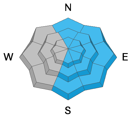
A CONSIDERABLE AVALANCHE DANGER exists on all wind drifted slopes at the mid and upper elevations. This danger is most pronounced on steep north to east to south facing slopes. Note that drifting may exist on any aspect and even down to the low elevation bands. Human triggered avalanches will be likely today. Some avalanches may have the potential to step down into older weaker layers 3-6' deep in localized terrain on west to north to southeast facing slopes.
Low
Moderate
Considerable
High
Extreme
Learn how to read the forecast here
Special Announcements
Monday's Livestream recording of the Wilson Glades avalanche accident debrief and review can be found on our YouTube channel HERE and on the UAC podcast.

Test your avalanche forecast comprehension skills by taking this short quiz after you read the forecast.
Go here to learn why we are asking you to take this quiz.
Weather and Snow
Now this is a good old fashioned Wasatch storm.
Overnight snow totals are up to 12" (0.41"SWE) in Ogden area mountains, pushing two day totals to nearly 18" in some areas.
Temperatures have plummeted with frontal passage, with many thermometers parked in the single digits and low teens.
West to northwest winds are blowing 15-20mph with gusts to 30 with hourly wind speeds 20-25mph along the Ogden skyline.

Snow will continue through the day with another 2-5" possible, perhaps more. There is some chance of DLE (Dreaded Lake Effect) this morning for the Ogden mountains before shifting aim to the Oquirrhs.
Westerly winds will blow 15-20 before veering to the north this afternoon. Skies will start to clear overnight.
Recent Avalanches
None.
You can read all the recent observations HERE.
Ad
Avalanche Problem #1
Wind Drifted Snow
Type
Location
Likelihood
Size
Description
I am anticipating fairly widespread and sensitive wind drifts at all elevations and more prominently located on north to east to south facing terrain. Cross-loading across the corrugated landscape from sub-ridges into gullies will also be general. The winds are perfect for wind loading and the low density 5-7% fluff will move with the wind's will. Drifts may be up to 2' deep along the higher elevations and may break above you in steep terrain. NOTE that the locator rose signifies where drifts are most problematic. Terrain channeling may have drifts on all aspects, particularly at the mid elevations and well off the ridgelines.

CORNICES HAVE GROWN SIGNFICANTLY IN THE PAST MONTH AND SHOULD BE TREATED WITH GREAT CAUTION.
Avalanche Problem #2
Persistent Weak Layer
Type
Location
Likelihood
Size
Description
Our deep slab avalanches, while becoming increasingly stubborn, can roar back to life with any additional stress, ie: heavy snowfall, strong winds, etc. Cornices may also be a good trigger for these larger avalanches. We haven't heard of any avalanches into this old layering 3-6' deep for quite some time, but they very much remain central to my route selection. These deeper slabs exist on west to north to southeast facing slopes at the mid and upper elevations are you are more likely to trigger these in steep, thin, rocky terrain or areas that may have avalanched during previous cycles.
These avalanches are tricky insofar that immediate signs of instability are often not present and it's easy to be lured onto slopes with other tracks, particularly when snow depths and snow tests might point "stable". The problem is the wide spatial variability across many slopes where you might hit the trigger point here (where the slab is thinner) but not there (where the slab is thicker).
My travel advice is to continue to avoid being on or beneath steep terrain where the facets in the basement exist.
Avalanche Problem #3
New Snow
Type
Location
Likelihood
Size
Description
Loose snow avalanches (sluffs) may be expected in the new snow on all aspects on slopes approaching 40° in steepness. Loose snow avalanches will start at a point (they're also known as point-releases) and fan out, picking up mass and speed, depending upon the fall line below. I anticipate that these may run naturally this morning and with provocation but become more stable as the day wears on. Note that natural new snow avalanches run during times of higher snowfall intensity.
General Announcements
Please visit this website with information about Responsible Winter Recreation by the Utah Office of Outdoor Recreation.

This information does not apply to developed ski areas or highways where avalanche control is normally done. This forecast is from the U.S.D.A. Forest Service, which is solely responsible for its content. This forecast describes general avalanche conditions and local variations always occur.