Donate to Our Spring Campaign or Bid on our Spring Auction to Support Forecasting

Forecast for the Ogden Area Mountains

Greg Gagne
Issued by Greg Gagne on
Friday morning, February 19, 2021
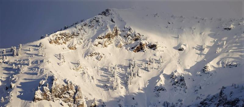
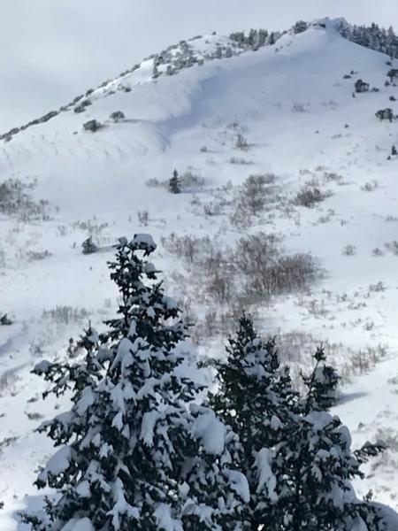
The avalanche danger is HIGH on upper elevation aspects facing west, through north, and southeast where human-triggered avalanches are very likely. Travel in avalanche terrain on these aspects and elevations is not recommended. On upper elevation aspects facing south and southwest, as well as mid- elevations slopes, the avalanche danger is CONSIDERABLE where human-triggered avalanches are likely. Low elevations have a MODERATE danger where human-triggered avalanches are possible.
Any avalanche you trigger may step down into deeply-buried weak layers, creating very large and destructive avalanches 6-8' deep and hundreds of feet wide.

The storm snow continues to settle out and is providing excellent travel and riding conditions on lower-angled slopes. We've had six avalanche fatalities already in Utah this season. Please set a very wide margin of safety.
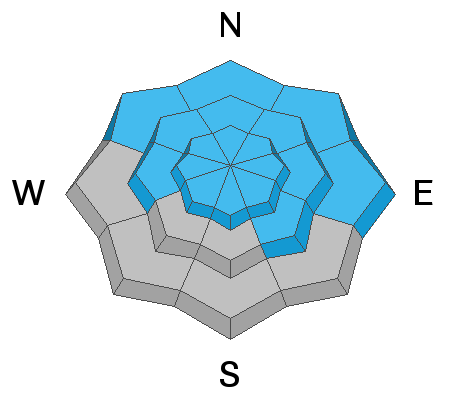
Low
Moderate
Considerable
High
Extreme
Learn how to read the forecast here
Special Avalanche Bulletin
Conditions are perfect for avalanche accidents. Heavy snowfall and drifting from strong winds have overloaded an exceptionally weak snowpack leading to extremely dangerous avalanche conditions.
All the fresh Utah powder will likely lure people into dangerous avalanche terrain, and people are likely to trigger deadly avalanches. A brief break in the weather will allow the avalanche danger to drop slightly; however, people can still trigger large and deadly avalanches if they venture onto steep slopes.
  • Avalanches triggered by people could be extremely large, very dangerous, unexpected, and deadly.
  • The Utah Avalanche Center recommends people avoid travel on or underneath slopes steeper than about 30 degrees in the backcountry for the next several days.
  • Even if you are experienced and have the proper avalanche safety equipment, you should still avoid all steep slopes in the backcountry.
Special Announcements
On Monday, February 22, at 7 PM, the UAC will hold an online meeting where we will review the tragic Wilson Glades avalanche accident, followed by a Q & A period. This Zoom meeting will be limited to 1,000 guests. A link for signing up will appear on UAC social media channels as well as these Special Announcements.
Weather and Snow
Currently, skies are mostly cloudy and temperatures - on the rise since Thursday evening - range through the upper teens and low 20's F. Winds are westerly and have also increased overnight. At the mid-elevations wind speeds are averaging in the teens and 20's mph, with gusts in the 30's mph. Along the upper-elevation ridges, winds are averaging in the 30's with gusts near 50 mph.
For today, expect periods of light snow with perhaps 2-3" by the afternoon. Temperatures will be in the low to mid 20's F with westerly winds remaining moderate to strong. At the mid-elevations winds will average in the teens and 20's, with gusts in the 30's mph. At the upper elevations, winds will average in the 20's and 30's with gusts in the 40's mph.
After a break later today, snow will redevelop overnight, with a decent storm on Saturday where we may see an additional 3-" of snowfall.
Recent Avalanches
No backcountry avalanches were reported from the Ogden-area mountains on Thursday. Brian Smith provides a nice observation from lower elevations on the North Ogden divide. Clearing skies made for viewing of some of the recent natural avalanche activity. The photo below shows some of the natural activity on Ben Lomond from North Ogden.
Further south in the Bountiful mountains, a rider came across a 4' deep natural avalanche on an east aspect on a slope that was possibly wind-loaded.
Clear skies also allowed control work to be performed by helicopter in some of the large slide paths in Big Cottonwood Canyon in the Salt Lake mountains. Thanks to Powderbirds and UDOT for this footage of Stairs Gulch. It's about 2 minutes long, but worthy of your time!
Ad
Avalanche Problem #1
Persistent Weak Layer
Type
Location
Likelihood
Size
Description
In the past week, we have added 2-3 feet of snow containing up to 3 inches of water to a very weak and faceted snowpack in the Ogden-area mountains. Although it may be a little bit harder to trigger an avalanche failing in these deeply-buried weak layers, any avalanche you trigger will be very large and destructive - 4-6' deep and hundreds of feet wide. Or even larger.
The most suspect terrain continues to be the west through north through southeast facing aspects at mid and upper elevations. HOWEVER, with so much snowfall - upper elevation south-facing terrain and low elevation north-facing terrain may also produce avalanches that break on buried persistent weak layers. Avoid being on or underneath any slope steeper than 30 degrees where this persistent weak layer is present.
Keep in mind:
  • Avalanches can be triggered from a distance or below.
  • Avalanches are running downhill thousands of feet and crossing hiking trails and summer roads.
  • Any fresh wind slab or new snow avalanche may step down several feet into older snow.
  • Signs of instability, such as cracking or collapsing, might not be present today.
Avalanche Problem #2
Wind Drifted Snow
Type
Location
Likelihood
Size
Description
Winds have increased during the overnight hours and will persist into today. These winds will have plenty of fresh snow available for transport, and fresh wind drifts and likely at the mid - and especially upper - elevations. Although you are more likely to find fresh drifts on the leeward aspects facing north through southeast, terrain may channel and funnel winds, with wind drifts possible on any aspect. Watch for signs of sensitive wind drifted snow such as cracking. Any avalanche initially occurring in a fresh wind drift may step down into deeply-buried weak layers, creating a very large avalanche.
Brian Smith photo from North Ogden divide illustrates fresh wind drifts along an exposed ridgeline along the North Ogden Divide:
Also, watch for fresh cornices along exposed ridgelines. These cornices may be sensitive, and any cornice falls may also step down to deeply-buried weak layers.
General Announcements
Please visit this website with information about Responsible Winter Recreation by the Utah Office of Outdoor Recreation.

This information does not apply to developed ski areas or highways where avalanche control is normally done. This forecast is from the U.S.D.A. Forest Service, which is solely responsible for its content. This forecast describes general avalanche conditions and local variations always occur.