We are filled with grief to report four avalanche fatalities that occurred Saturday in the Wilson Glade of upper Mill Creek Canyon. The avalanche involved two separate parties. Our deepest condolences go out to the friends and families involved. Our deepest gratitude goes out to Wasatch Backcountry Rescue, Intermountain Lifeflight, the Department of Public Safety, the United States Forest Service, and Brighton, Solitude and Alta Ski Patrols for providing resources and support during this tragic accident.
We investigated the accident Sunday; our
preliminary report has been published. Please be patient and know the UAC staff is working around the clock to get the final report done.
The National Weather Service (NWS) has issued a Winter Storm Warning in effect from 08:00 pm tonight through Friday 11:00 pm. For today, we should see increasing clouds with some snow showers possible; however, any accumulations will only be a trace to a couple of inches. Mountain temperatures will climb into the upper 20's to low 30's at 8500'. Snow will begin to fill into the area this evening around 08:00 pm. Westerly winds are forecasted to increase later this afternoon and into the evening, with the strongest winds overnight.
The winds are currently blowing from the westerly direction at 10-15 mph gusting into 30's mph. The Ogden Skyline winds are moving much faster from the west and are blowing at speeds of 30-35 mph, gusting into the 40's & 50's mph. Mountain temperatures are mainly in the mid 20°F above about 7,400'. At Ben Lomond Trail (6,000'), the temperature reading was 38 °F.
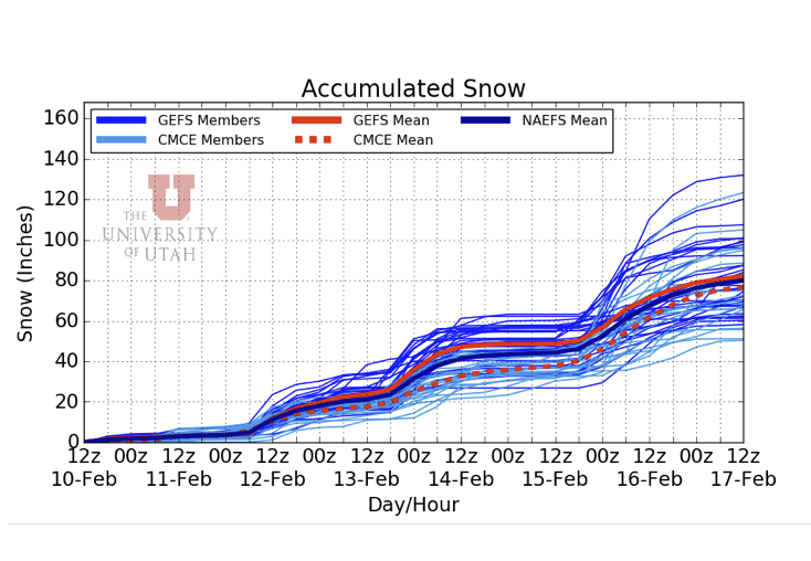
Buckle your seatbelts as we have a very active storm cycle forecasted. The first storm will be tonight into Friday, and I am seeing 8-14" (0.80"-1.2" swe) of snow by Friday evening. The next storm will be Saturday evening, lasting into Sunday with perhaps 12-16" of snow with another inch of water. Then the best looking storm is slated for Monday into Tuesday into Wednesday. By the end of the cycle on Thursday, we could see up to 4" of snow water equivalent and possibly 70" of snow.
Now the caveat; it's easy to get excited, but the truth is, the details on these storms are still a long way out, and we should sip the weather kool-aide instead of chugging it. I am a little skeptical that this will all shake out. But hey, it's going to snow. Stay tuned, and we will do our best to keep up to date with changing weather.
Yesterday, there were no new avalanches reported from the backcountry. However, we did get two reports of some older avalanche activity from the weekend's natural and human triggered cycle. One avalanche was from
Mineral Fork, roughly 1,000' wide, 2-3' feet deep, and running full track to the creek ~ 1,200' vertical. The second slide was from the Bountiful Sessions with about the same dimensions. Be sure to catch up on all the observations
HERE.