Donate to Our Spring Campaign or Bid on our Spring Auction to Support Forecasting

Forecast for the Ogden Area Mountains

Mark Staples
Issued by Mark Staples on
Wednesday morning, February 1, 2023
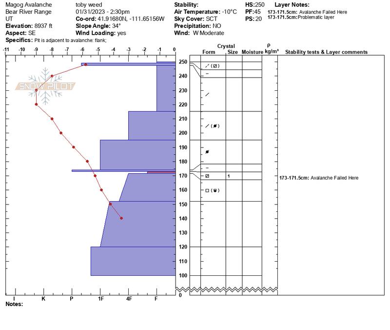
The avalanche danger is MODERATE at mid and upper elevations on south and west aspects where soft slab avalanches may break on a layer of facets near an ice crust buried about 2 feet deep.
The danger is LOW on all other slopes where this layer doesn't exist, but continue to look for slabs of wind drifted snow which may still produce an avalanche today.
Low
Moderate
Considerable
High
Extreme
Learn how to read the forecast here
Weather and Snow
This morning under clear skies temperatures range from 7-15 degrees F (about 15 degrees warmer than yesterday morning). Winds are averaging 11-17 mph gusting to 25 mph from both the NW and SW.
Today, winds will continue blowing as they are this morning. With clear skies and strong sunshine, temperatures will quickly rise into the upper 20s F but may feel warmer with strong sunshine.
Looking ahead, temperatures will continue to warm through the rest of the week with clear, sunny weather. Another storm may arrive Sunday/Monday.

Yesterday, sunny slopes received enough sunshine and warming and they should have an ice crust on them this morning which will soften as temperatures warm this morning. Most northerly and east facing slopes have fantastic powder.
Recent Avalanches
There hasn't been notable avalanche activity in the Ogden area mountains, but there have been plenty of slides near SLC and Logan that make me suspect similar conditions exist. What stands out are the slides that broke on a layer of very small facets next to an ice crust buried 2-3 feet deep like ones at:

See the full list of avalanche activity HERE and you can filter slides by region and date.
Ad
Avalanche Problem #1
Persistent Weak Layer
Type
Location
Likelihood
Size
Description
As described above, a layer of very small facets next to an ice crust has been producing slab avalanches. If the issue was solely the new snow, then this problem would have stabilized by now. Unfortunately this layer will continue to be a concern, but it shouldn't last nearly as long as other persistent weak layers. A process currently occurring again on the snow surface (described in this video) likely formed this layer early last week during cold temperatures and brief moment of clear weather.
Here's the good news - This layer mostly exists on slopes that should have an ice crust on the surface this morning, and those are ones you will likely avoid anyway. Northerly facing slopes seem to lack this layer and will have better snow. I don't think east facing slopes have this layer but there is some uncertainty because it has been found on east facing slopes north of Logan.
Photo below of a slide that brok on this layer near Logan near Tony Grove on Mt Magog (southeast 9600') that was 3' deep and 1500' wide.
Toby's profile from the flank of this avalanche. Similar layering has been found from Provo to Logan.
Avalanche Problem #2
Wind Drifted Snow
Type
Location
Likelihood
Size
Description
Winds have mostly been light over the last few days except at the highest elevations. They blew from the west and northwest and formed slabs of wind drifted snow over last weekend that many people triggered. Today, these many of these winds slabs should have stabilized, but winds may still be moving some snow. I would still look for and avoid these wind slabs.
General Announcements
This information does not apply to developed ski areas or highways where avalanche control is normally done. This forecast is from the U.S.D.A. Forest Service, which is solely responsible for its content. This forecast describes general avalanche conditions and local variations always occur.