Donate to Our Spring Campaign or Bid on our Spring Auction to Support Forecasting

Forecast for the Ogden Area Mountains

Greg Gagne
Issued by Greg Gagne on
Friday morning, December 10, 2021
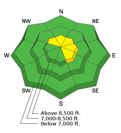
The avalanche danger is MODERATE on upper-elevation slopes facing northwest through southeast where avalanches involving shallow pockets of fresh wind drifts are possible. Loose sluffs in the new snow are also possible, espcially during any period of higher precipitation intensity.
Low
Moderate
Considerable
High
Extreme
Learn how to read the forecast here
Special Announcements
This week is the third annual Avalanche Awareness Week in Utah. A lot is going on with over 20 different events around the state. You can find all the events HERE.
Batteries for Beacons runs through Dec 19. Get free batteries for your transceiver and a chance to win 1 of 10 Black Diamond Rescue Kits, 1 of 3 Mammut Barryvox transceivers, or 1 of 3 BCA Tracker transceivers. Stop at a participating shop, fill out our survey and get a free set of batteries. Don't need batteries, but still want a chance to win? Simply fill out the survey to be registered.
Weather and Snow
Currently - Temperatures are in the low single digits and winds are out of the west/northwest. At mid elevations, wind speeds are averaging less than 10 mph with gusts in the low 20's mph. Atop Mt. Ogden, winds are averaging in the 20's with gusts in the 30's mph.
Snowfall began around 6 am on Thursday morning with approximate 24-hour snow totals of 4-9".
For today, temperatures will rise into the low teens with 3-6" of snowfall expected. Winds will be from the west/northwest. A mid elevations, winds will average in the low teens with gusts in the 20's. Along upper-elevation ridges, wind speeds will average in the 20's mph with gusts in the 30's mph.
Recent Avalanches
We received no backcountry observations from the Ogden mountains for Thursday. Derek DeBruin and a few friends submitted excellent observations from Wednesday, providing an overview of snowpack conditions prior to the recent storm for Rodeo Ridge and Cutler Ridge.
Ad
Avalanche Problem #1
Wind Drifted Snow
Type
Location
Likelihood
Size
Description
Snowfall from yesterday and today, combined with west/northwest winds, may create shallow pockets of sensitive wind drifts at the upper elevations. Any snowfall today may also be sensitive, especially during any period of higher precipitation intensity. The slopes that have the most concern are those above 8,000' on northerly aspects where there may be weak, faceted snow underneath.
Although any avalanches are likely to be shallow, getting caught in any avalanche will have significant consequences with early-season obstacles such as rocks, tree stumps, and downed timber.