Donate to Our Spring Campaign or Bid on our Spring Auction to Support Forecasting

Forecast for the Ogden Area Mountains

Dave Kelly
Issued by Dave Kelly on
Tuesday morning, January 10, 2023
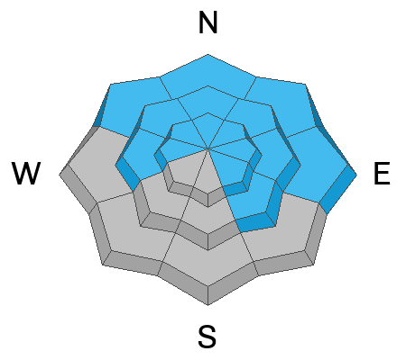
The avalanche danger is HIGH at upper elevations where I would expect that natural avalanches are occurring. The avalanche danger is CONSIDERABLE in mid and low elevation terrain where human triggered avalanches are likely.

Travel in the highest elevation terrain is not recommended and cautious route finding should be used when traveling at mid and low elevations. Avoid travel on slopes steeper than 30 degrees or below steep terrain.
Low
Moderate
Considerable
High
Extreme
Learn how to read the forecast here
Weather and Snow
Overnight mountain locations reported 9-12" of new snow and 1-1.4" of water. Storm totals are 11-14" snow and 1.3-1.6" of water. It is currently snowing, and the last few hours have been steady inch an hour snowfall rates.
Trailhead temperatures are in the low 30's F while the temperatures at the 9,000' ridgelines are in the mid 20's F. Winds are blowing southwest 30 gusting to 45 MPH at the 9000' ridgelines
Today will bring continued clouds and 5-9" of snow. Temperatures will be 30-34 F. Winds will blow from the southwest 30 gusting to 50 MPH at the 9000' ridgelines. The freezing level will hover between 6,000' and 7,000' throughout the day.

The National Weather Service has issued a winter weather advisory effective until 5:00pm on Wednesday. This morning's southerly flow storm will bring higher density snow before winds shift to the northwest bringing lower density snow Tuesday afternoon through Wednesday.
Recent Avalanches
No avalanches were reported from the Ogden backcountry yesterday.
Ad
Avalanche Problem #1
New Snow
Type
Location
Likelihood
Size
Description
I would expect natural avalanches this morning in the steepest terrain and expect they will continue as long as it is snowing hard. There is a possibility of wet loose avalanche activity if it starts to rain on the new snow that fell overnight.
Avalanche Problem #2
Wind Drifted Snow
Type
Location
Likelihood
Size
Description
New and developed pillows of wind drifted snow can be found in upper and mid elevation terrain. These areas of wind-drifted snow have now been buried under new snow and will be harder to see.

Watch for sensitive cornices primarily on north-east facing ridgelines where snow has been transported over the last twenty-four hours.

Any wind drifted avalanche may step down into a deeper buried weak layer resulting in a larger avalanche.
Avalanche Problem #3
Persistent Weak Layer
Type
Location
Likelihood
Size
Description
The deeply-buried persistent weak layer (PWL) from November continues to gain strength and it has become harder to initiate an avalanche on this layer. It may take a significant trigger - a large cornice fall, multiple riders on a slope, or another avalanche adding more weight to the snowpack to trigger this layer. Any avalanche triggered on this weak faceted snow would 2-7' deep.
Areas where you are more likely to trigger this PWL are shallow thinner spots or on rocky ridges.

This observation from north of Powder Mountain shows a propagation saw test failure on these facets
Video:Talty
General Announcements
This information does not apply to developed ski areas or highways where avalanche control is normally done. This forecast is from the U.S.D.A. Forest Service, which is solely responsible for its content. This forecast describes general avalanche conditions and local variations always occur.